Dynamos in NatureHow can you create electric currents? One way is a battery, which does so by chemical processes. However, the current which we use every day in our home is generated in other ways--by electric generators, also known as "dynamos."
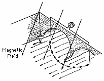
All dynamos are based on principles found by Michael Faraday a few years after Oersted's discovery--basically, an electric current is created in a wire or electric conductor that moves through the region of magnetic forces (also known as "magnetic field"). In the generators of the power station, the wires rotate near electromagnets (or vice versa, the magnets rotate and the wires do not move). But the conductor can also be a conducting fluid flowing through a magnetic field. Faraday himself in 1832 tried to measure electric currents created this way, by the flow of London's river Thames across the magnetic field of the earth. The circuit was completed by a copper wire, strung across Waterloo Bridge in London, its ends dipping into the water. The current was too weak to be measured, but the principle was correct. We believe that the uneven rotation of the hot gases on the Sun--fastest near the equator, as the motion of sunspots shows--helps create electric currents in this manner. Not all details of the process are understood, because we can only guess what goes on under the surface of the Sun, in regions we cannot see, but the web site explains some of the ideas.
Reversals of the Earth's
The drawing below is again taken of Gilbert's book. "Auster" is south--remember "Australia"--and the smith is hammering a bar of hot iron, as it cools down while lined up in the north-south direction. Gilbert noticed that such a bar became weakly magnetized, with the polarity appropriate to its direction, and viewed it as the iron being "reborn" and in the process (like a baby that starts breathing) acquiring the magnetism of its mother, the Earth. |
 |
(Bricks and pottery, by the way, also do so. Magnetic observatories often keep sensitive instruments in wooden sheds, because brick walls may affect observations.)
Early in this century scientists realized that ancient lava flows may tell about variations of the Earth's magnetic field in the past. They were in for a surprise: some old lavas had the same north-south polarity as the Earth has now, but others had the opposite polarity. For a while the issue was confused by certain chemical processes, which can reverse the polarity of some magnetic minerals. But in 1952 Jan Hospers, studying basalts in Iceland, came with convincing proof that the first impression was the right one--that there existed long periods in the past, when the north-south magnetic polarity of the Earth was reversed.
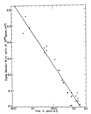 |
Comparing his observations with recent ones--and with those made in-between--shows that the north-south field of the Earth is weakening by about 5% per century, maybe even a bit faster. No one of course guarantees the trend will continue for 2000 years, until the poles are reversed. In fact, the field has twists and features that are added on top of the simple two-pole structure, and these seem to be getting stronger.
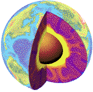
What it all suggests is that inside the core of the Earth, where flows of liquid iron create the currents responsible for the magnetism of the Earth, the flow pattern can be quite complicated. There may be several independent eddies, and some grow stronger, others weaker, changing the pattern. One can construct systems where the currents of eddy A produce the magnetic field of eddy B, and vice versa, and such systems can in principle create magnetic reversals.
The Sun also has a polar magnetic field, and its polarity reverses in each sunspot cycle, every 11 years or so. More about that, again, on the web site.
- By the way--I get a fair amount of e-mail related to the web site. One question that comes up again and again (and you too may get it from a student) is--what happens to life during magnetic reversals? When the magnetic field of the Earth no longer protects us from space radiation, is our life in danger?
The answer is no. It is true that the magnetic field deflects space radiation, but the protection is very weak near the magnetic poles, e.g. in parts of Alaska. Yet people live and work there. Our true protection is the atmosphere, equivalent to about 10-12 feet of concrete. Future astronauts on Mars--which only has a weak magnetic field and a very thin atmosphere--may have to get into underground shelters when the Sun lets go, but we here are safe.
(Also, the magnetic field apparently does not vanish during reversals--it just gets weaker and more complex. If it did completely vanish for a really long time, it is just possible that the solar wind would indeed erode our atmosphere.)
Ocean Floor Magnetization
 |
| Alfred Wegener |
He formulated his ideas in a military hospital, while recovering from wounds suffered as an army officer in World War I. He based them, not just on the similarity of coastlines but also on the matching of geological formations on opposite sides of the ocean, even matching animal and plant life. He viewed continents as slabs of lighter rock, floating like ice floes on denser minerals below them. That was an accepted idea in geology, and still is.
But he also imagined them drifting, like ice floes in the ocean, and with that most geologists disagreed. Those lower rocks are tough stuff, they argued, and unlike the ocean, they would strongly resist any motion through them.
For about 50 years only a few supporters were found. Wegener himself died in 1931, caught by bad weather while traveling by dogsled across Greenland. What gave his ideas new credibility were reversals of the Earth's magnetic field and measurements of the magnetization of the ocean floor.
 |
Up to the 1950s, magnetic fields were measured by magnetic needles suspended in one way or another. Then some quite sensitive electronic instruments were developed, and these could be put on a wooden boat, towed behind a ship, or in a package suspended from an airplane. Oil companies started mapping magnetic irregularities from airplanes, hoping to find clues to oil deposits: on land, all the patterns they found were irregular.
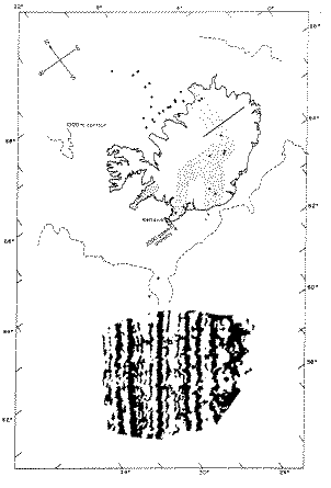 |
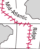
Magnetization near the Mid-Atlantic Ridge |
Maps like this one led to a new view, by which continents were indeed moving. America was moving away from Europe and Africa, though not exactly the way Wegener had proposed. Rather, the deeper layers on which they floated--the "lithospheric plates"-- were pulled away to both sides of the mid-Atlantic ridge, at about one inch per year, carrying the continents with them. As they pulled apart, volcanic lava oozed up into the crack between them, hardened into basalt, and became part of one plate or the other.
And here is where magnetism entered the picture: as the lava hardened into basalt, it acquired a magnetic polarity, due to the magnetic field of the Earth. However, every half-million years or so, the polarity of the Earth's field reversed, and the basalt, too, became magnetized reversely. The Atlantic seafloor was like a giant magnetic tape (or rather, twin tapes moving in opposite directions), unreeling at a rate of one inch a year and recording each polarity reversal of the magnetic field as long stripe of magnetization.
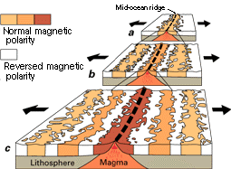 |
| Schematic View of Sea-Floor Spreading |