Instruments can measure the magnetization of basalt. Therefore, if a volcano has produced many lava flows over a past period, scientists can analyze the magnetizations of the various flows and from them get an idea on how the direction of the local Earth's field varied in the past. Surprisingly, this procedure suggested that times existed when the magnetization had the opposite direction from today's. All sorts of explanation were proposed, but in the end the only one which passed all tests was that in the distant past, indeed, the magnetic polarity of the Earth was sometimes reversed.
Ocean Floor Magnetism
 |
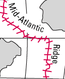
| Mid-Atlantic Ridge |
In the 1950s electronic magnetometers were developed. Unlike the older instruments, based on the compass needle, these could be towed behind an airplane or a ship. Oil companies were soon using them aboard airplanes, mapping the weak magnetism of rocks to help locate oil deposits. On land, the patterns of this magnetism seemed jumbled, with no meaningful order.
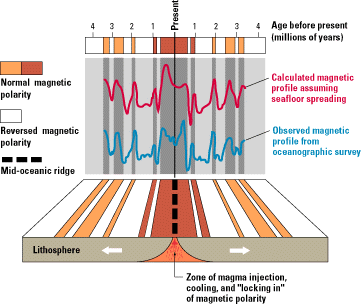
Extending those measurements to the oceans, around 1960, revealed a surprising difference. In the ocean floor the magnetization was orderly, arranged in long strips. The strips on the Atlantic ocean floor, in particular, all seemed parallel to the "mid-Atlantic ridge." That is a volcanic ridge running roughly north-to-south (with some zigs and zags), halfway between Europe-Africa and America. It is marked by the focus-points of earthquakes and by some volcanic islands, and more recently it was explored by research submarines, which have at times observed lava oozing out at its crest.
 |
| Ocean floor magnetization (USGS figure) |
Not only were the magnetic strips lined-up with the central ridge, but their structure and distribution seemed remarkably symmetric on both sides: if (say) a narrow-wide pair of strips was observed at a certain distance east of the ridge, its mirror image was also found at about the same distance to the west.
Sea-Floor Spreading
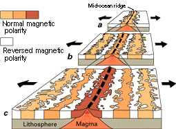
This puzzling picture was explained in 1962 by Lawrence Morley (whose article was rejected by the journals as too speculative) and by Drummond Matthews and Fred Vine. They all proposed that the sea floor was in constant motion, pulling away from the central ridge at a rate of about one inch (2.5 cm) per year.
As the "plates" on each side are pulled away, lava emerges from the middle, solidifies and "records" the prevailing magnetic field. The newly formed basalt sticks to the plates and is also pulled away--some of it towards Europe and Africa, some towards America. Every half million years, on the average, the Earth's magnetic polarity reverses, and so does the magnetization of the ocean floor. Each strip therefore represents an epoch of one or the other magnetic polarity, and the symmetry is also explained. It is as if the sea-floor was a giant tape recorder, with twin tapes emerging from the mid-Atlantic ridge, recording the Earth's magnetism at the time they emerge and then traveling in opposite directions. Similar magnetic strips were also observed in all other oceans.
 |
| Sea-floor spreading (USGS figure) |
If the sea-floor was moving, then continents adjoining them might share that motion, just as Wegener had guessed. The main difference now seems to be that rather than pushing their way through a semi-fluid on which they float, the continents (or some of them) ride on top of "conveyer belts" in that fluid. These are the "plates" which emerge at mid-ocean and go down again (at least in some cases) at the deep oceanic trenches, like the ones found near Japan or in the Caribbean Sea.
The science of the shaping of the Earth's crust goes by the name "tectonics," and the process described here is the essence of "plate tectonics" by the Earth's crust consists of distinct plates which are continually rearranged, sometimes carrying along continents or parts of continents. The entire motion is indeed driven by the Earth's internal heat.
The Pacific plate bordering California, for instance, is slowly rotating, moving northwards. The edge of California is attached to that plate and also moves northwards, but the bulk of the continent does not. The juncture between the two, where one slips by the other, follows in part the famous San Andreas fault.
Author and Curator: Dr. David P. Stern
Mail to Dr.Stern: earthmag("at" symbol)phy6.org
Last updated 23 February 2008
|